
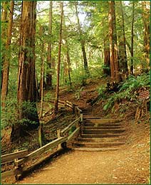
Muir Woods features several trails that offer a variety of habitats, terrain, and degree of hiking difficulty.
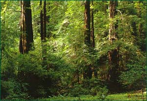
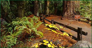 Muir Woods' main trail begins at the visitor center and follows Redwood Creek on both sides of the stream. Though a level, easy stroll, you can shorten your walk by crossing on the second or third of four bridges and returning to the visitor center. The path is wide, paved and wheelchair and stroller accessible. Numbered signs begin after the second bridge. The numbers correspond to the stops described in our Nature Trail Booklet. You'll find a close-up map of the main trail on the inside cover of our guide.
![]()
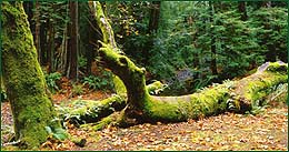
This is a great route to take if you want to get away from the busy main trail and do just a little hiking. Look for the "Hillside Trail" sign after the fourth bridge on the main trail. Walk uphill, about 40 yards, to where the path curves along the canyon edge and doubles back around a side stream. The easy, dirt path offers a higher vantage point from which to view the forest.
![]()
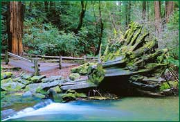
 You'll find a resting spot off Fern Creek Trail, which travels along lush Fern Creek through a forested redwood canyon. Look for the trail head sign a quarter-mile past Cathedral Grove and, a short distance later, Kent Tree, a 220-foot Douglas-fir favored by William Kent, who donated Muir Woods to the U.S. government. After following the stream for a mile, you'll find drinking water, restrooms, tables and sunshine! This spot, named the "Alice Eastwood" camp, is the original terminus of a "gravity" rail car line that carried passengers to the top of Mt. Tam and, by the draw of gravity, down into Muir Woods in the early 1900s. The Plevin cut, originally part of the rail line, will bring you back to the main Muir Woods trail.
![]()
Want to climb to a view of Mt. Tamalpais, the Pacific Ocean and San Francisco? Take the Dipsea Trail. Start across the bridge off the lower/overflow parking lot. A half-mile steep grade through lush, fern-lined forest brings you out of the canyon to an exposed ridge. The trail eases as it passes through grassland. After the trail enters a redwood forest for a quarter-mile of gradual uphill walking, you reach the Ben Johnson Trail cutoff. Follow it in a slow descent back to the main Muir Woods trail. For a longer hike, stay on the Dipsea Trail to Stinson Beach.
![]()
 If you have time for a half-day hike, and want an ideal resting spot, choose this trail loop. Muir Woods' main trail becomes the Bootjack Trail after the fourth bridge, and follows Redwood Creek until the forest opens at Van Wyck Meadow, a historic gathering site. To the left begins a trail portion built during World War I by the Tamalpais Conservation Club. You'll cross many canyons while remaining on level ground. To catch the Stapleveldt Trail, take the left fork (TCC Trail) at the trail markers. Switchbacks bring you down to Ben Johnson Trail, leading you back to Muir Woods.
![]()
 The Ocean View Trail (Note: Also called the Panoramic Trail - Was named the Ocean View Trail when a fire cleared the view to the ocean, the trees have since regrown.) originates in Muir Woods and travels up to the Panoramic Highway.
Although steep in parts, the trail is mostly gentle climbs. You'll witness the range of plant life on Mt. Tamalpais: redwoods within the canyons, tan oak, coastal live oak, madrone and Douglas-fir on the middle elevations, and chaparral topping higher slopes. The next two hikes start in Muir Woods and connect with the Ocean View Trail.
![]()
Lost Trail gets its name from being covered for 30 years after a 1930s landslide. To visit a quiet, peaceful forest, walk the Lost Trail. Take the Ocean View Trail (look for the sign), off the main trail. After approximately 1.3 miles, take the Lost Trail turnoff on the left and descend through deep forests of Douglas-fir into the redwoods. Lost Trail ends at Fern Creek Trail; turn left and follow Fern Creek Trail back to Muir Woods.

 This half-day hike offers a stop midway at the Tourist Club for a rest and views. Follow the Ocean View Trail for 1.5 miles, then turn right where it intersects the trail parallel to the Panoramic Highway. After a short distance, turn off onto Redwood Trail, a level path that curves around the canyons, maintaining an elevation of 800 feet.
Catch the views of the Pacific Ocean and Muir Woods. After 1.7 miles on Redwood Trail, you'll reach the Tourist Club, established in 1912. Although a sign at the Tourist Club directs you toward Muir Woods, the route is steep, dangerous and an erosion problem. Instead, take the Sun Trail loop 0.7 miles, cross Muir Woods Road and catch the Dipsea Trail back to Muir Woods.